Latest Issue
Volume 3, Issue 2
December 2024

Prevention and Treatment of Natural Disasters (PTND) is an international, peer-reviewed, open-access journal devoted to original research work on all aspects of natural hazards, reflecting on the mechanisms of natural disasters, disaster prevention, treatment, and risk management, as well as community resilience assessment and enhancement under natural disasters. PTND is interested in all types of natural disasters, with an emphasis on weather and climate disasters (e.g., tropical cyclones, floods, wildfires, and extreme winds) and geological disasters (e.g., earthquakes, tsunamis, volcanic eruptions, and landslides).

  • E-ISSN: 2753-7544
  • Frequency: Semiyearly publication
  • Language: English
  • E-mail: ptnd@ukscip.com

Submit Manuscript

Latest Published Articles

Article

Investigation of Seismic Behavior of the Historical Yeşiltepe Bridge

Historic arch bridges, a common feature of Turkish infrastructure, represent a significant aspect of the country’s cultural heritage. To ensure their continued existence and preservation, it is essential to conduct a detailed examination of their structural features and behaviours. This study aimed to investigate the performance of the historic Yeşiltepe Bridge under earthquake conditions. To achieve this, the bridge was modelled using the SAP2000 finite element software, enabling a deeper understanding of its structure and the prediction of its behaviour during an earthquake. In order to ascertain the dynamic behaviour of the historical bridge, modal analysis and nonlinear time history analysis were conducted. The results of the modal analysis yielded period values, mass participation rates and mode shapes for the bridge. The time history analysis yielded displacement, base shear force and stress values for the historical structure, which were subsequently presented in graphical form. The data obtained from the study enabled the identification of the critical regions of the structure exhibiting the highest stress concentration values.

Read more

Article

Assessing the Impact of Climate Change on Glacial Lake Outburst Flood (GLOF) in Eastern Hindu Kush Region Using Integrated Geo-Statistical and Spatial Hydrological Approach

Glacier retreat, a major impact of climate change that continues to occur in many parts of the world, continues to increase the risk of glacial lake outburst floods (GLOFs) in northern Pakistan. The rapid melting of glaciers in the mountains of Northern Pakistan, including the Hindu Kush, the Himalayas and the Karakoram, the rapid melting of glacier has led to the formation of 3044 glacial lakes, with 33 identified as particularly vulnerable to GLOFs. This study uses remote sensing and geographic information systems (GIS) methods for mapping and representing GLOFs. Based on the observational data of lake area, volume, and depth, empirical equations are developed through statistical methods. Only two lakes, Chitral-GL2 and Swat-G31, are classified as lakes with high potential for GLOF. Through modeling techniques using HEC-RAS and HEC-GeoRAS spatial hydrological models integrated with GIS remote sensing, the spatial extent and depth of inundations under different lake volumes are assessed. The analysis reveals that a total area of 20.56 km2 is susceptible to submersion by GLOFs, with Chitral-GL2 flooding area of 14.80 km2 and Swat-GL31 5.79 km2. Different land types are impacted by critical water depths, with built-up and agricultural lands 2.7 km2 totally, and barren lands 8.93 km2 under different flood depths ranging from less than 5 m to over 15 m.

Read more

Article

Advancing Forest-Fire Management: Exploring Sensor Networks, Data Mining Techniques, and SVM Algorithm for Prediction

Forest-fire is a pressing global problem that has far-reaching effects on human life and the environment, with climate change exacerbating their frequency and intensity. There is an urgent need for advanced predictive systems to mitigate these impacts. To address this issue, this study introduces a forest-fire prediction framework integrating wireless sensor networks (WSNs), data analysis, and machine learning. Sensor nodes deployed in a forest area collected real-time meteorological data, which was transmitted using LoRaWAN technology. Data mining techniques prepared the data for analysis using the SVM algorithm, revealing relationships between meteorological parameters and wildfire risk. The SVM model demonstrated an accuracy of 86% in classifying forest-fire risk levels based on temperature, humidity, wind speed, and rainfall data. The integrated framework of WSNs and the SVM algorithm provides a high-accuracy model for forest-fire risk prediction. The model is compared to the Canadian Forest Fire Hazard Rating System to validate its accuracy, demonstrating strong agreement with historical records and reports. The model's practical implications include efficient management, early detection, and prevention strategies. However, the model's limitations suggest avenues for future research, we should consider broader geographic applications and using advanced machine-learning methods to enhance the model's predictive capabilities.

Read more

Article

Big Data Challenges and Opportunities for Disaster Early Warning System

The application of big data in early warning systems (EWS) for multi-hazard risk management is becoming increasingly popular due to its enormous potential. Nevertheless, despite noteworthy achievements, there are still several enduring obstacles. This study aims to evaluate the advantages and difficulties through a comprehensive SWOT (strengths, weaknesses, opportunities, threats) analysis and the use of existing literature. An extensive literature analysis was conducted, incorporating perspectives of researchers from diverse background investigating both technical and social elements. The study results showed several notable strengths, such as unmatched accuracy and comprehensiveness, the incorporation of several data sources to improve prediction and forecasting, and the exploitation of up-to-the-minute data. On the other hand, problems, such as insufficient monitoring of hazards and a scarcity of interconnected sensors, especially common in less developed countries, were recognized. Lack of adequate coverage leaves a substantial percentage of the population vulnerable to disaster risks as a result of inadequate early warning systems. Ultimately, although big data offers significant possibilities, its complete capacity remains unexplored in the least developing nations due to existing obstacles, such as shortage of skilled worker, data accuracy and privacy which can be solved by enhancing technology education, capacity building, and practice. The objective of this study is to help such nations identify and overcome underlying challenges by implementing suitable measures.


Read more

Article

Modelling Past Tsunamis in European Waters

A research model to simulate the propagation of tsunamis caused by different mechanisms was developed in this paper. These mechanisms are submarine earthquakes, landslides and collapse of volcano calderas. The model is based upon the non-linear shallow-water hydrodynamic equations with horizontal viscosity and friction with the seabed. It also includes a flooding/drying algorithm. This model was tested by applying it to several past tsunamis and comparisons of results with available data and/or other models. The objective of this paper is to present a summary on the application of the model to historical tsunamis occurred in European waters: Atlantic Ocean, Mediterranean Sea and Caspian Sea. Additionally, two application examples on how the research model can be used to confront different candidate tsunami sources and to discard scenarios of catastrophic floodings initially attributed to tsunamis presented: the Santorini tsunami sequence and the flooding of the Gulf of Tartessos in SW Spain.

Read more

Article

Some Considerations on the Seismic Event of 23 November 1980 (Southern Italy)

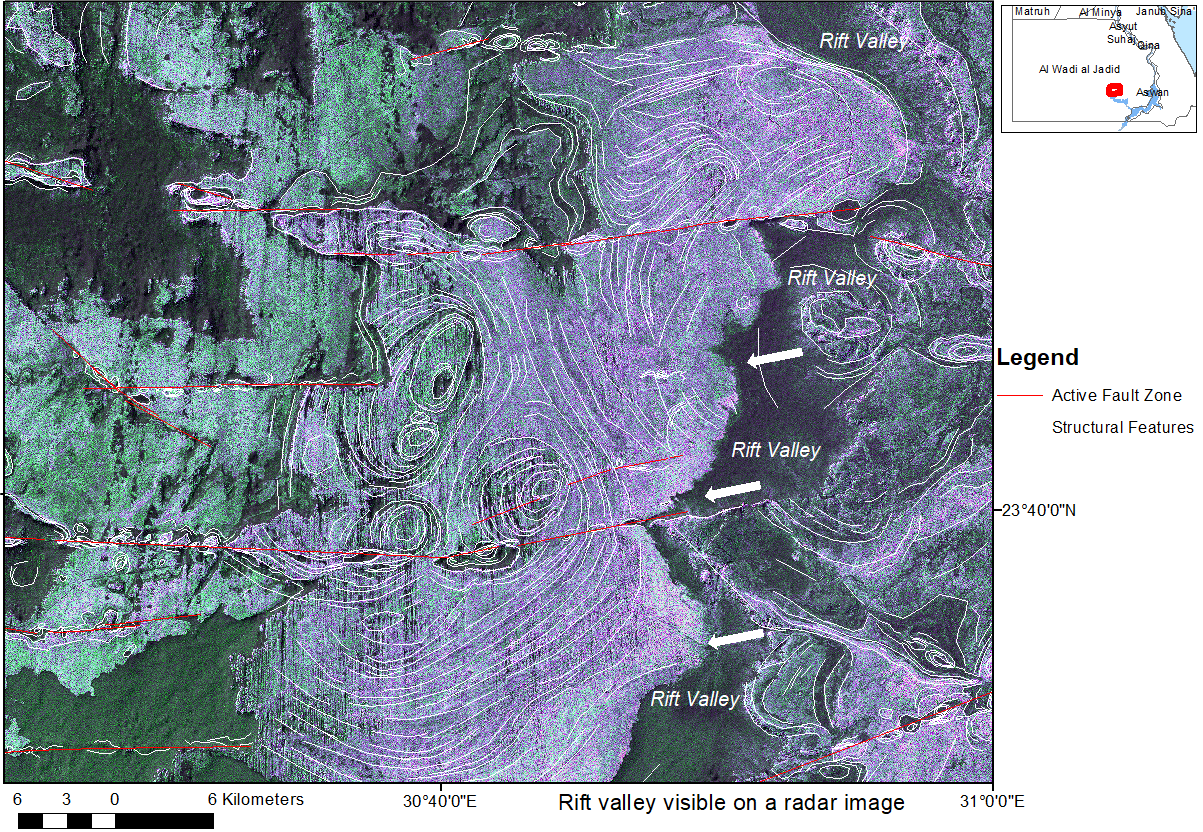
More than forty years after the 23 November 1980 earthquake, which devastated the Campania and Basilicata regions, causing the destruction of a large number of towns and the death of around three thousand people, we have tried, through a large survey, to understand how and to what extent the urban fabric and the most affected communities have been rebuilt. Our main objective was to show, on one side, the commitment of the scientific community, and on the other the transitions that have led from the emergency to reconstruction. Of the Apenninic towns Conza della Campania, Laviano, Lioni, Santomenna, and others, where the devastation was almost total, we have tried to give an iconographic vision of the post-earthquake phase through the change in the urban layout. The partial or total reconstruction of the towns has taken place most of the time in situ, only in some cases by relocating buildings to neighboring areas, as happened in Conza della Campania, Bisaccia and Romagnano al Monte. Reconstruction was carried out mainly of anti-seismic buildings and only in some cases recovering pre-existing buildings in historic centres; reconstruction was completed after a very long period, in some cases lasting over thirty years, inevitably passing through a dramatic experience of the population in temporary settlements of various kinds, from tents, caravans, railway carriages, to containers, and finally to thermo-igloos and to prefabricated wooden chalet-type. A very complex and detailed reconstruction was linked to factors not only territorial, economic and political but also conditioned unfortunately by the non-negligible intervention of organized crime.

Read more

Communication

Evaluating the Inequity Impact of Climate Change on Urban and Rural Communities

Extreme weather (heat waves, floods, drought, tropical storms, and tornados) has intensified as a result of climate change. In particular, the effects of climatic hazards on remote communities are more severe due their limited access to resources (e.g., health, socio-economics, sewer, stormwater, and drinking water systems), causing a dichotomy between urban cities and remote regions. For example, unknown and potentially emerging contaminants present in floodwater have detrimental effects on rural communities, causing an increased number of deaths given their lack of access to public health resources. Meanwhile, urban cities continuously rely on the natural resources of those same rural communities to confront climate change-induced natural disasters. This paper contributes to the development of a climate change resilience framework for urban and rural communities, exploring the approaches in mitigating disparate impacts between the two communities. Several discussions from the perspectives of policy and technical methodologies are provided, including watershed management. Furthermore, through analysis, this study outlays future directions and suggested resolutions of the inequity impact of climate change on rural and urban communities.

Read more

Article

Earthquakes Three-Stage Early Warning and Short-Term Prediction

Among the anomalous geophysical phenomena observed preceding earthquakes, specific attention has been given to VLF/LF, ULF (very low frequency/low frequency, ultra-low frequency) electromagnetic (EM) emissions, recorded before earthquakes, because of an interesting correlation between them and seismic activity. Numerous scientific papers have been published on this topic, providing convincing evidence of these processes observed using ground-based and satellite ground-based observations during the preparation for the earthquake. These phenomena are detectable both at laboratory and geological scales. The authors of this paper have used an avalanche-like unstable geological model of fault formation and a model of the generation of electromagnetic emissions detected before the earthquakes to prove the prediction capabilities of VLF/LF EM emissions. The first gives a clear imagination of earthquake preparation in all stages in the focal area from the beginning of the micro-cracks appearing to the final formation of fault. Another one, based on electrodynamics, explains the EM emissions origination process and offers a formula that analytically connects the observed frequency of  EM radiation with the linear size of the emitted body (fault). It is worth emphasizing the synthesis and rather harmonious relation of the mentioned models. Based on the above models conducted studies clearly show that the description of a qualitative avalanche-unstable geological model of fault formation using VLF/LF EM radiation data made it possible to quantitatively characterize the full cycle of preparation and occurrence of earthquake process. Namely, in the case of VLF/LF emissions monitoring, the beginning of the “avalanche process” of ruptures is considered the first stage of early warning of an incoming earthquake. The so-called EM emissions “silence” period is assessed as the second stage of early warning. The third early warning or an alarm about an incoming earthquake may be announced immediately at the moment of the first anomaly appearance subsequently the “silence” period. This article offers the method of earthquake three-step early warning and short-term (hourly) prediction.

Read more

Article

Analyzing the Vulnerability of Residential Buildings in the City of Chaitén: A Focus on an Extreme Event Scenario in a Disrupted River Corridor Following the Cataclysmic Volcanic Eruption of 2008

Pillared on the hydrodynamic simulation of an extreme flooding scenario, we subsequently evaluated the physical vulnerability of residential buildings utilizing an ad hoc developed indicator-based methodology. This method aimed to quantify the expected loss for each affected residential structure. The outcome of this assessment facilitated the creation of a detailed risk map, allowing for the identification of hotspots that require immediate prioritization in mitigation efforts. The results of our study revealed a concentrated impact of the flood, particularly in the northern sector of the city. Within this region, four high-risk areas were pinpointed, comprising 70 homes predominantly situated close to the active channel zones. Notably, our findings underscored that twelve residential buildings, located at shorter distances from the river, are particularly susceptible to the impacts of the flood, as indicated by the physical vulnerability index values. It is important to highlight that the developed methodology is specifically tailored for the analysis of lightweight, one or two-storey houses with exteriors constructed from wood and zinc plates, as opposed to structures built with concrete or stone masonry. This distinction is crucial, given the prevalence of such building types in the Chilean Patagonian region. We recommend extending the application of this methodology to other urban areas in the region, where analogous impacts are possible and similar architectural patterns are common.

Read more

Article

The Convincing Cosmic Energy Gravitational Genesis of the Strongest Geomagnetic Anomalies of the Magnetic Field of the Earth

The author presents convincing evidence of the cosmic (planetary and solar) energy gravitational origin (related to the maximal and minimal combined planetary and solar integral energy gravitational influences on the internal rigid core of the Earth) of the maximal temporal intensifications of the global magnetic processes of the Earth. In fairly good agreement with the calculated date 2007.416666666 AD (of the local minimal planetary and solar integral energy gravitational influence on the internal rigid core), it was observed the very rapid changes of the geomagnetic field near the date March 2007 AD (corresponding approximately to 19-20 April 2007 AD). This fairly good agreement gives the additional convincing argument that the date March 2007 AD can be considered as the possible beginning of the geomagnetic reversal during the evaluated range (2007÷2216) AD. The strong magnetic anomaly occurred on 6 January 2020 AD in perfect agreement with the calculated date 2020.016666667 AD (corresponding to 6 January 2020 AD) related to the local maximal planetary and solar integral energy gravitational influence on the internal rigid core. In fairly good agreement with the calculated date 2023.26666666 AD (corresponding approximately to 7 April 2023 AD) of the local maximal planetary and solar integral energy gravitational influence on the internal rigid core, it was observed the strongest (during the last 6 years) magnetic anomaly on 23 March 2023 AD. These convincing agreements demonstrate the physical validity of the established global prediction thermohydrogravidynamic principles, which can be considered as the proven physical basis for the development of the general unified geophysical theory (describing the possible geomagnetic reversal during the evaluated  range (2007 ÷ 2216) AD) combining the Special Theory of Relativity, the relativistic electrodynamics and the relativistic theory of the non-stationary gravitation, which can be developed based on the established physical analogy between the established relation  for the energy flux (of the gravitational energy) and the Lorentz’s calibration condition (for the vector potential related with the scalar potential of the non-stationary electromagnetic field).

Read more

Article

Overview of Fault Zones Based on Remote Sensing Data as Contribution to the Safety of Infrastructure and Land Use in Southern Egypt

Part of a requisite for natural hazard awareness and damage prevention in Egypt is the detailed monitoring of surface fault zones. The inventory of active faults and their risk assessment is an essential contribution to the safety of settlements, land use and infrastructure (railroads, highways, pipelines) and to damage prevention. Thus, this study aims to contribute to the detection, inventory, and documentation of fault zones. Surface faulting hazard assessment considers any surface consequences caused by surface near faults such as abrupt horizontal and vertical displacements and rotations, or mass movements after stronger earthquakes. Long-term, aseismic, slow-creeping movements along fault zones have to be considered as well. Southern Egypt offers unique and optimal conditions for the research of fault zones and their different structural expressions and conditions because of the dry desert climate conditions and relatively low human influence on the landscape in extended areas, especially for the investigation of different types of faults, their interactions with each other and the outcropping rocks, and fault-related deformation structures. Volcanic activity has been influenced in the geologic past often by larger fault zones as dike intrusions, volcanic cones and plugs or craters occur concentrated along these zones of weakness facilitating the uprise of magma. Larger fault zones are crossing reservoir areas. Surface water intrusions into deep-seated faults have played a role in triggering earthquake swarms in the reservoir areas during the last decades. Mapping of active faults is not only an important but also a cost-intense task when carried out in the field or when using geodetic and geophysical data. In the scope of this study, fault detection was carried out based on different open-source satellite data (Landsat 8 and 9, Sentinel 2 optical data, Sentinel 1 and ALOSPASAR radar data, and Google Earth and Bing Map high-resolution satellite images) from the southern part of Egypt. Faults were digitized using ArcGIS and QGIS software. An inventory of fault-related structural features (depressions, ridges, rotation structures, etc.) and rift zones was elaborated based on remote sensing data. An overview of different types of faults and their related structures as well as their interactions with their host rock conditions could be achieved. By merging the inventory results with infrastructural and land use data, critical areas with potential damage risk were pointed out.

Read more

Review

For the Classification of Anomalous Geophysical Fields that Existed Prior to an Earthquake

The consolidated paper presents work carried out in the sphere of earthquake problems. On the base of theoretical and experimental studies, it is shown earthquake prediction possibility. There are discussed earthquake indicators and triggering exogenous factors in the example of the Caucasus region. Because the earthquake preparation process causes anomalous changes with complex characteristics in various geophysical fields, it is given scientifically proven suggestions for the classification of these fields as earthquake precursors, indicators, and triggering factors. It offers a short-term plan for future work in the earthquake prediction direction.


Read more
View All Issues