
Article
Overview of Fault Zones Based on Remote Sensing Data as Contribution to the Safety of Infrastructure and Land Use in Southern Egypt
 Download

This work is licensed under a Creative Commons Attribution 4.0 International License.
Copyright
The authors shall retain the copyright of their work but allow the Publisher to publish, copy, distribute, and convey the work.
License
Prevention and Treatment of Natural Disasters (PTND) publishes accepted manuscripts under Creative Commons Attribution 4.0 International (CC BY 4.0). Authors who submit their papers for publication by Prevention and Treatment of Natural Disasters (PTND) agree to have the CC BY 4.0 license applied to their work, and that anyone is allowed to reuse the article or part of it free of charge for any purpose, including commercial use. As long as the author and original source is properly cited, anyone may copy, redistribute, reuse and transform the content.
Authors

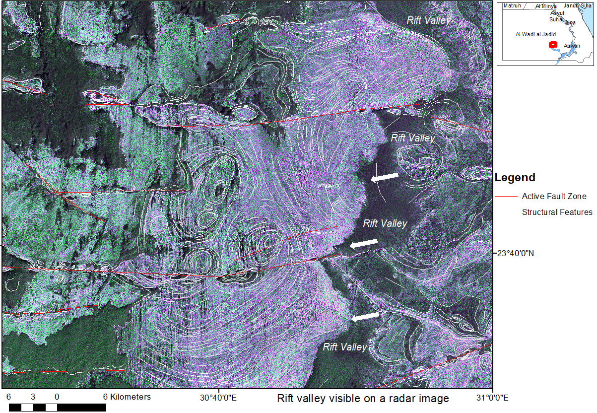
Part of a requisite for natural hazard awareness and damage prevention in Egypt is the detailed monitoring of surface fault zones. The inventory of active faults and their risk assessment is an essential contribution to the safety of settlements, land use and infrastructure (railroads, highways, pipelines) and to damage prevention. Thus, this study aims to contribute to the detection, inventory, and documentation of fault zones. Surface faulting hazard assessment considers any surface consequences caused by surface near faults such as abrupt horizontal and vertical displacements and rotations, or mass movements after stronger earthquakes. Long-term, aseismic, slow-creeping movements along fault zones have to be considered as well. Southern Egypt offers unique and optimal conditions for the research of fault zones and their different structural expressions and conditions because of the dry desert climate conditions and relatively low human influence on the landscape in extended areas, especially for the investigation of different types of faults, their interactions with each other and the outcropping rocks, and fault-related deformation structures. Volcanic activity has been influenced in the geologic past often by larger fault zones as dike intrusions, volcanic cones and plugs or craters occur concentrated along these zones of weakness facilitating the uprise of magma. Larger fault zones are crossing reservoir areas. Surface water intrusions into deep-seated faults have played a role in triggering earthquake swarms in the reservoir areas during the last decades. Mapping of active faults is not only an important but also a cost-intense task when carried out in the field or when using geodetic and geophysical data. In the scope of this study, fault detection was carried out based on different open-source satellite data (Landsat 8 and 9, Sentinel 2 optical data, Sentinel 1 and ALOSPASAR radar data, and Google Earth and Bing Map high-resolution satellite images) from the southern part of Egypt. Faults were digitized using ArcGIS and QGIS software. An inventory of fault-related structural features (depressions, ridges, rotation structures, etc.) and rift zones was elaborated based on remote sensing data. An overview of different types of faults and their related structures as well as their interactions with their host rock conditions could be achieved. By merging the inventory results with infrastructural and land use data, critical areas with potential damage risk were pointed out.
Keywords:
fault zones fault related structures remote sensing GIS southern-EgyptReferences
- Moustafa, S.S.R.; Abdalzaher, M.S.; Abdelhafiez, H.E. Seismo-lineaments in Egypt:Analysis and implications for active tectonic structures and earthquake magnitudes. Remote Sens. 2022, 14(23), 6151.
- Genidi, H.; Saleh, M.; Mohamed, A.M.; Othman, A.; El Mahmoudi, A. Recent estimates of the ground deformation from remote sensing and terrestrial data around the High Dam Area, Aswan, Egypt. Egypt. J. Remote Sens. Space Sci. 2023, 26(3), 403–414.
- Geofabrik's free download server for OpenStreetMap data. Available online: http://download.geofabrik.de/africa.html
- Mohamed, A.E.A.; El-Hadidy, M.; Deif, A.; Elenean, K.A. Seismic hazard studies in Egypt. NRIAG J. Astron. Geophys. 2012, 1(2), 119–140.
- Saadalla, H.; Abdel–aal, A.A.K.; Mohamed, A.; El-Faragawy, K. Characteristics of earthquakes recorded around the high dam lake with comparison to natural earthquakes using waveform inversion and source spectra. Pure Appl. Geophys. 2020, 177, 3667–3695.
- Trinh, P.; Vinh, H.; Huong, N.; Liem, N. Active fault segmentation and seismic hazard in Hoa-Binh reservoir, Vietnam. Cent. Eur. J. Geosci. 2013, 5(2), 223–235.
- Global Active Faults Database (GEM GAF-DB). Available online: https://blogs.openquake.org/hazard/global-active-fault-viewer/
- Styron, R.; Marco Pagani, M. The GEM global active faults database. Earthq. Spectra. 2020, 36(1_suppl), 160–180.
- Jerris, T.J. Development of structural basins and domes on the Sinn El-Kaddab Plateau, Egypt: insights from in situ data and application of moderate resolution orbital imagery of the Seiyal Fault. Master’s thesis, Missouri University of Science and Technology, Rolla, 2014.
- Hamimi, Z; Hagag, W.; Osman, R.; El-Bialy, M.; Abu El-Nadr, I.; Fadel, M. The active Kalabsha Fault Zone in Southern Egypt: Detecting faulting activity using field-structural data and EMR-technique, and implications for seismic hazard assessment. Arab. J. Geosci. 2018, 11, 421.
- Rashwan, M.; Sawires, R.; Radwan, A.M.; Sparacino, F.; Peláez, J.A.; Palano, M. Crustal strain and stress fields in Egypt from geodetic and seismological data. Remote Sens. 2021, 13(7), 1398.
- El Bohoty, M.; Ghamry ,E.; Hamed, A.; Khalifa, M.; Taha, A.; Meneisy, A. Surface and subsurface structural mapping for delineating the active emergency spillway fault, Aswan, Egypt, using integrated geophysical data. Acta Geophys. 2023.
- Bauer, H.; Rogowitz, A.; Habler, G.; Grasemann, B.; Decker, K. Interaction of frictional and plastic deformation mechanisms in a clay-carbonate strike-slip fault (Northern Calcareous Alps, Austria). J. Struct. Geol. 2023, 166, 104774.
- JAXA/METI, satellite data accessed through ASF DAAC. Available online: https://www.asf.alaska.edu/ (accessed from May to September 2023).
- Paillou, P. Mapping palaeohydrography in deserts: Contribution from space-borne imaging radar. Water. 2017, 9(3), 194.
- Earth Explorer. Available online: https://earthexplorer.usgs.gov/ (accessed from May 2023 to January 2024).
- ESA Copernicus Open Access Hub. Available online: https://dataspace.copernicus.eu/
- JAXA, PALSAR-2 Global Forest/Non-forest Map “2022". Available online: https://www.eorc.jaxa.jp/ALOS/en/palsar_fnf/data/2022/map.htm
- Arab Nubia Group Blog, GIS, Remote Sensing & General, Applications. Available online: https://blog.arabnubia.com/
- Geologic Map of Egypt, 1981, 1: 2 Mio, Egyptian Geological Survey and Mining Authority, Cairo, Egypt. Available online: https://esdac.jrc.ec.europa.eu/content/geologic-map-egypt
- Geomorphic Evolution of The Kurkur-Dungul area in Response to Tectonic Uplifting and ClimaticChanges, South Western Desert, Egypt. Available online: https://www.academia.edu/53375547/Geomorphic_Evolution_of_The_Kurkur_Dungul_area_in_Response_to_Tectonic_Uplifting_and_Climatic_Changes_South_Western_Desert_Egypt
- Alrefaee, H.A. Crustal modeling of the central part of the Northern Western Desert, Egypt using gravity data. J. Afr. Earth Sci. 2017, 129, 72–81.
- Sakran, S.; Said, S.M. Structural setting and kinematics of nubian fault system, se western desert, Egypt: An example of multi-reactivated intraplate strike-slip faults. J. Struct. Geol. 2018, 107, 93–108,
- Saleh, S.; Pamukcu, O.; Brimich, L. The major tectonic boundaries of the Northern Red Sea rift, Egypt derived from geophysical data analysis. Contrib. Geophys. Geod. 2017, 47(3), 149–199.
- Saleh, M.; Masson, F.; Mohamed, A.M.S.; Boy, J.P.; Abou-Aly, N.; Ali Rayan, A. Recent ground deformation around lake Nasser using GPS and InSAR, Aswan, Egypt. Tectonophysics. 2018, 744, 310–321.
- Zhang, S.; Ma, X. How does in situ stress rotate within a fault zone? Insights from explicit modeling of the frictional, fractured rock mass. J. Geophys. Res.: Solid Earth. 2021, 126(11), e2021JB022348.
- Tewksbury, B.; Mehrtens, C.J.; Gohlke, S.A.; Tarabees, E.A.; Hogan, J.P. Constraints from Mesozoic siliciclastic cover rocks and satellite image analysis on the slip history of regional E-W faults in the southeast Western Desert, Egypt. J. Afr. Earth Sci. 2017, 136, 119–135.
- ISC Bulletin: interactive event catalogue search. Available online: http://www.isc.ac.uk/iscbulletin/search/catalogue/interactive/
- Earthquake data. Available online: https://earthquake.usgs.gov/earthquakes/search/ (accessed on 14 September 2023).
- Earthquake data. Available online: http://www.emsc-csem.org/ (accessed on 20 September 2023).
- Mohamed, A.S.; Hassib, G.H.; AbouAly, N.; El-Kutb, A. Evaluation of recent crustal deformation and seismicity in spillway fault area, Aswan, Egypt. NRIAG J. Astron. Geophys. 2022, 11(1), 325–336.
- Alam, A.; Ahmad, S.; Bhat, M.S.; Ahmad, B. Tectonic evolution of Kashmir basin in northwest Himalayas. Geomorphol. 2015, 239, 114–126.
- Atmaoui, N. Development of Pull-Apart Basins and associated Structures by the Riedel-Shear Mechanism: Insight from scaled Clay Analogue Models. Ph.D. thesis, Fakultät für Geowissenschaften der Ruhr-Universität Bochum zur Erlangung des Doktorgrades der Naturwissenschaften, Bochum, 2005.
- Еl Aala, A.K.A.; Nabawyc, B.S; Aqееld, A.; Abidie, A. Gеohazards assessment of the karstifiеd limestone cliffs for safe urban constructions, Sohag, West Nile Valley, Egypt. J. Afr. Earth Sci. 2020, 161, 103671.
- Shah, A.A.; bin Yassin, A.M.H.E.; bin Haji Irwan, M.I.I. Is pull-apart basin tectonic model feasible for the formation of Kashmir basin, NW Himalaya. Scientia Bruneiana. 2017, 16(1).
- Nkodia, H.M.D-V.; Miyouna, T.; Delvaux, D.; Boudzoumou, F. Flower structures in sandstones of the Paleozoic Inkisi Group (Brazzaville, Republic of Congo): Evidence for two major strike-slip fault systems and geodynamic implications. South Afr. J. Geol. 2020, 123(4), 531–550.
- Baharizan, F.Z.; Ismail, M.S. The brittleness and ductility of shale from Setap shale, Miri, Sarawak. IOP Conf. Ser.: Earth Environ. Sci. 2022, 1003, 012012.
- Abdel Zaher, M.; Elbarbary, S.; El-Shahat, A.; Mesbah, H.; Embaby, A. Geothermal resources in Egypt integrated with GIS-based analysis. J. Volcanol. Geotherm. Res. 2018, 365, 1–12.
- Abdel Zaher, M.; Elbarbary, S. Investigation of Geothermal resources in Egypt using geophysical data. In Proceedings of the World Geothermal Congress, 2020+1, Reykjavik, Iceland, 24–27 October 2021.
- Theilen-Willige, B. Remote sensing and geographic information system (GIS) contribution to the inventory and investigation of dikes in Egypt. Mediterr. J. Basic Appl. Sci. 2023, 7(3), 60–84.
- Theilen-Willige, B. Overview of circular structures of various origins and sizes in Egypt as a contribution to natural hazard data mining based on remote sensing data and geoinformation systems (GIS) analysis. Prevention and Treatment of Natural Disasters. 2023, 2(2), 7–19.
- Salama, A.; Hussein, H.; Abdelazim, M.; El-Nader Iman, A. Reinvestigation of the 1978 Gilf El Kebir earthquake, Egypt. NRIAG J. Astron. Geophys. 2023, 12(1), 143–148.
- Sherif, M.A.; Badreldin, H. Present-day stress field in Egypt based on a comprehensive and updated earthquake focal mechanisms catalog. Pure Appl. Geophys. 2019, 176, 4729–4760.
- PreventionWeb, the global knowledge-sharing platform for disaster risk reduction and resilience. Available online: https://www.preventionweb.net/