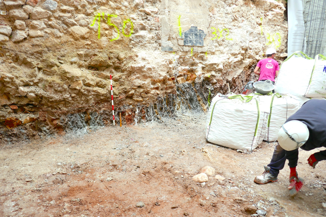
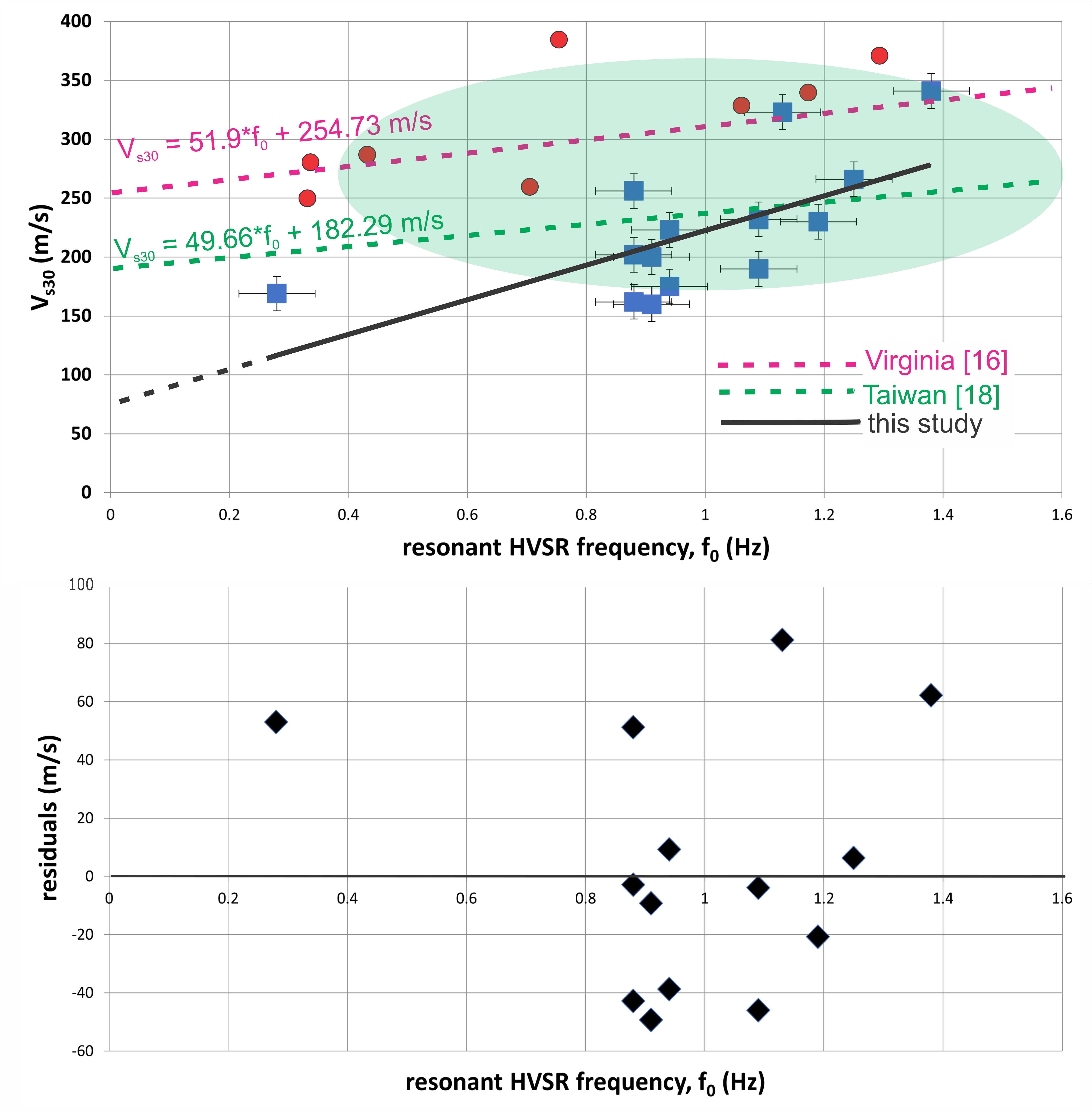
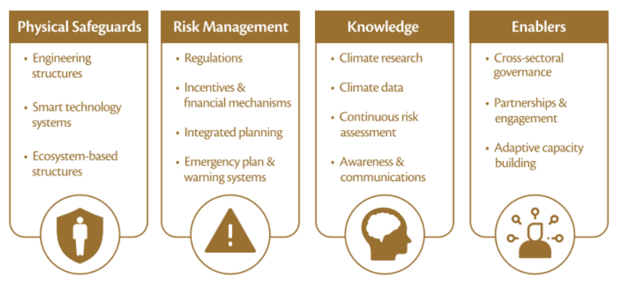
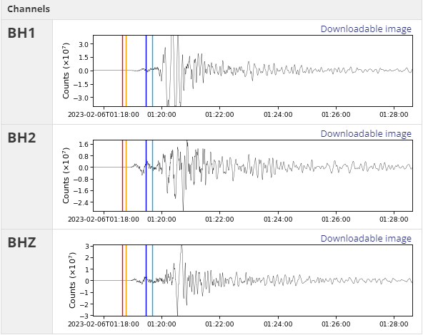
Prevention and Treatment of Natural Disasters

Latest Issue
Volume 4, Issue 1
June 2025

Prevention and Treatment of Natural Disasters (PTND) is an international, peer-reviewed, open-access journal devoted to original research work on all aspects of natural hazards, reflecting on the mechanisms of natural disasters, disaster prevention, treatment, and risk management, as well as community resilience assessment and enhancement under natural disasters. PTND is interested in all types of natural disasters, with an emphasis on weather and climate disasters (e.g., tropical cyclones, floods, wildfires, and extreme winds) and geological disasters (e.g., earthquakes, tsunamis, volcanic eruptions, and landslides).

  • E-ISSN: 2753-7544
  • Frequency: Semiyearly publication
  • Language: English
  • E-mail: ptnd@ukscip.com

Submit Manuscript

Latest Published Articles

Article Article ID: 894

Towards Recovery: An Analysis of Post‑Disaster Recovery Practices in Australia

The occurrence of disasters is increasing in frequency and magnitude in Australia as a result of climate change. According to projections, disasters related to climate change and also other types of disasters are expected to impose an increasing burden on Australian communities and will increasingly challenge the capabilities of governments and other agencies to manage the post-disaster response and recovery. This paper explores whether Australian post-disaster recovery practices can be augmented to support and empower those impacted by catastrophic disasters. The research used a case study methodology to explore examples of major recent disasters in Australia and suggests how disaster recovery can be augmented by extending existing practices and/or utilising alternative practices. Recovery practices were identified from the literature and the selected case studies, and were analysed for importance, effectiveness and future potential improvements. Community engagement has been identified as a key factor in assessing the appropriate disaster recovery decisions and actions. The research on the disaster context and practices coupled with a review of the current scholarly discourse has been used to propose an indicative community recovery support matrix as a way of assisting governments and agencies involved in disaster recovery to develop strategies in the initial stage of supporting impacted communities.

Read more

Article Article ID: 332

Modeling Dependence of Peak Floor Acceleration and Maximum Interstory Drift Ratios with Gaussian Copulas

This study introduces a multivariate demand model for Engineering Demand Parameters (EDPs) in Performance Based Seismic Design (PBSD), utilizing Gaussian copulas to characterize the dependence structure of the demand vector. The effectiveness of this approach is assessed by comparing EDPs generated using Gaussian copulas against those assumed under a joint lognormal distribution. This validation study is further carried forward to values of economic loss for the four special steel moment frames obtained via the three sets of EDPs. The Performance Assessment Calculation Tool (PACT) developed by the Federal Emergency Management Agency (FEMA) P-58 (2015) is used for loss estimation. Results indicate that using copulas to represent the dependence structure of EDPs better captures the characteristics of the population of EDPs rather than assuming a joint lognormal distribution. Distributions of economic loss generated using copulas match the loss generated from the true observations of EDPs better than loss generated assuming a joint lognormal distribution. The sample size of the selected and scaled ground motions required for the generation of realizations of building response via nonlinear dynamic analysis is also investigated, which proves to yield more accurate values of response but, at the expense of using a larger number of initial observations.

Read more

ArticleArticle ID: 876

An application of hyperspectral PRISMA dataset to characterize the Solfa-tara crater, Southern Italy

The Campi Flegrei area (CF) is a highly significant site for scientific investigation due to its dual importance in both Earth and Planetary Sciences. On the one hand, from a natural hazard perspective, CF is considered one of the most dangerous volcanoes on Earth because of its proximity to a densely populated urban area—the Neapolitan district, which hosts approximately three million people living between CF, Vesuvius, and Ischia. On the other hand, from a planetary science viewpoint, the high-temperature geothermal environment of the Solfatara crater serves as a terrestrial analogue to early rocky bodies within the Solar System and thus represents a prime target for astrobiological research. As part of a comprehensive site characterization, we present preliminary results using PRISMA data for the mineralogical mapping of acidic surface deposits in the Solfatara crater and the remote detection of fumarolic gases. Two PRISMA datasets were analyzed: one acquired before and one after the most significant earthquake in the area in the past 40 years, which occurred on 27 September 2023. Our initial findings reveal some variations in carbon dioxide emissions from the fumarolic field.

Read more

ArticleArticle ID: 331

Flood Modeling and Emergency Planning for Dam Failure: Projections in Calabria (Italy)

A dam is a hydraulic structure made of natural materials, such as earth, or artificial ones, such as concrete, whose main function is to block a watercourse to create an artificial basin for multiple purposes, including irrigation, energy production, flow regulation, and protection. These structures allow for the storage of large quantities of water, which, in the event of a collapse, can have devastating effects on human lives and the surrounding territory. Therefore, regulations prescribe strict safety checks and provide operational guidelines for civil protection activities and emergency plans. Through several case studies in Calabria, a region of southern Italy, this paper analyzes Italian regulations concerning scenarios in which it is necessary to safely empty the reservoir behind the dam following an earthquake and to enable the consequent civil protection activities and emergency planning. The paper also describes the coupled hydrological and hydrodynamic modeling carried out using HEC-HMS and HEC-RAS, respectively, to define three thresholds for each dam in accordance with Italian regulations. These thresholds are: the maximum flow rate for emptying dams located within the hydraulic pertinence areas downstream; the attention flow rate for dam discharge, beyond which hydraulic criticalities may occur; and incremental thresholds that identify scenarios with greater hydraulic criticalities.

Read more

CommunicationArticle ID: 324

A Mathematical Exploration of Pre-Earthquake Seismicity

Understanding the dynamics of pre-earthquake seismicity is crucial for advancing earthquake forecast and risk assessment. In this paper, we embark on a mathematical exploration of pre-earthquake seismic activity, aiming to elucidate the underlying patterns and mechanisms leading up to major seismic events. Leveraging probabilistic modeling techniques, we analyze historical seismic data to identify precursory signals and assess their predictive value. Our investigation encompasses the study of foreshock activity, preceding earthquakes, shedding light on the temporal and spatial characteristics of seismic activity prior to the main shock events. Through mathematical modeling and simulation, we aim to unveil the complex interplay of factors contributing to pre-earthquake seismicity, with implications for enhancing earthquake forecasting capabilities and disaster preparedness efforts. This research contributes to the ongoing endeavor to unravel the mysteries of earthquake occurrence, ultimately striving towards a more resilient and proactive approach to seismic risk management. This study introduces a novel mathematical framework for analyzing pre-earthquake seismic activity, leveraging a 15-day foreshock window and machine learning techniques to predict seismic events. The approach addresses gaps in existing methodologies by incorporating comprehensive feature engineering and a robust random forest classification model. Additionally, we draw upon insights from prior studies, such as Kumazawa et al. (2020) and Luo et al. (2023), which emphasize the significance of spatial-temporal dynamics and natural orthogonal expansion methods in identifying seismic precursors. By integrating interdisciplinary methodologies and advanced machine learning models, this study bridges critical gaps in real-time predictive capabilities, offering a tailored approach for region-specific seismic forecasting.

ArticleArticle ID: 303

Designing Post-Fire Flood Protection Techniques for a Real Event in Central Greece

Wildfires pose a growing global danger for ecosystems and human activities. The degraded ecosystem functions of burnt sites, include, among others, shifts in hydrological processes, land cover, vegetation, and soil erosion, that make them more vulnerable to flood and extreme sediment transport risks. Several post-fire erosion and flood protection treatments (PFPs) have been developed to avoid and mitigate such consequences and risks. The Mediterranean region faces severe climate change challenges that are projected to escalate the wildfire and post-fire flood risks. However, there is limited research on the dynamics of post-fire flood risks and their mitigation through the design of the appropriate PFPs. This paper aims to cover this gap by simulating a real post-fire flash-flood event in Central Greece, and design the PFPs for this case study, considering their suitability and costs. An integrated framework was used to represent the flood under the baseline scenario: the storm conditions that caused the flood were simulated using the atmospheric model WRF-ARW; the burn extent, severity, and the flood extent were retrieved through remote sensing analyses; and a HEC-RAS hydraulic-hydrodynamic model was developed to simulate the flood event, applying the rain-on-grid technique. Several PFPs were assessed, and certain channel- and barrier-based PFPs were selected as the most suitable for the study area. The recommended PFPs were spatially represented within a geographic information system (GIS). Moreover, we present a detailed analysis of their expected costs. This study provides an interdisciplinary and transferable framework for understanding and enhancing the flood resilience of burnt sites.

Read more

ArticleArticle ID: 293

Assessing Drought Pattern Through Satellite Based Observation in the Koshi River Basin, Nepal

Drought identification is crucial for various environmental and ecological considerations. This study observed the spatial and temporal variations of drought based on the satellite-derived Vegetation Condition Index (VCI) across different time scales—i.e., winter, pre-monsoon, and annual—compared with remotely sensed Land Surface Temperature (LST) and precipitation. MODIS NDVI products, LST, and meteorological station data for rainfall were used. VCI was employed to classify drought conditions. Pearson correlation analysis was conducted between VCI and both LST and precipitation. The results show that severe drought was detected in 2001 during the winter and pre-monsoon seasons, and also in 2006 during the pre-monsoon season. No severe drought was observed on the annual time scale, although moderate droughts occurred in several years. The VCI trends increased at rates of 1.29 yr⁻¹, 1.52 yr⁻¹, and 1.72 yr⁻¹ for the annual, winter, and pre-monsoon periods, respectively. Conversely, LST decreased at rates of 0.007 yr⁻¹, 0.044 yr⁻¹, and 0.028 yr⁻¹ during the same periods. The increased VCI and decreased LST indicate a declining trend in drought severity on a yearly scale. The positively increasing Anomaly of VCI (AVCI) suggests improved vegetation growth under moist soil conditions. VCI was also positively correlated with precipitation on the annual and pre-monsoon time scales, but negatively correlated during the winter season. The correlation between LST and VCI was negative across all time scales and was more significant during the pre-monsoon and winter seasons. This study contributes to understanding vegetation-based drought and its relationship with temperature and precipitation in the Koshi Basin, Nepal.

Read more

ArticleArticle ID: 291

Investigation of Seismic Behavior of the Historical Yeşiltepe Bridge

Historic arch bridges, a common feature of Turkish infrastructure, represent a significant aspect of the country’s cultural heritage. To ensure their continued existence and preservation, it is essential to conduct a detailed examination of their structural features and behaviours. This study aimed to investigate the performance of the historic Yeşiltepe Bridge under earthquake conditions. To achieve this, the bridge was modelled using the SAP2000 finite element software, enabling a deeper understanding of its structure and the prediction of its behaviour during an earthquake. In order to ascertain the dynamic behaviour of the historical bridge, modal analysis and nonlinear time history analysis were conducted. The results of the modal analysis yielded period values, mass participation rates and mode shapes for the bridge. The time history analysis yielded displacement, base shear force and stress values for the historical structure, which were subsequently presented in graphical form. The data obtained from the study enabled the identification of the critical regions of the structure exhibiting the highest stress concentration values.

Read more

ArticleArticle ID: 271

Advancing Forest-Fire Management: Exploring Sensor Networks, Data Mining Techniques, and SVM Algorithm for Prediction

Forest-fire is a pressing global problem that has far-reaching effects on human life and the environment, with climate change exacerbating their frequency and intensity. There is an urgent need for advanced predictive systems to mitigate these impacts. To address this issue, this study introduces a forest-fire prediction framework integrating wireless sensor networks (WSNs), data analysis, and machine learning. Sensor nodes deployed in a forest area collected real-time meteorological data, which was transmitted using LoRaWAN technology. Data mining techniques prepared the data for analysis using the SVM algorithm, revealing relationships between meteorological parameters and wildfire risk. The SVM model demonstrated an accuracy of 86% in classifying forest-fire risk levels based on temperature, humidity, wind speed, and rainfall data. The integrated framework of WSNs and the SVM algorithm provides a high-accuracy model for forest-fire risk prediction. The model is compared to the Canadian Forest Fire Hazard Rating System to validate its accuracy, demonstrating strong agreement with historical records and reports. The model's practical implications include efficient management, early detection, and prevention strategies. However, the model's limitations suggest avenues for future research, we should consider broader geographic applications and using advanced machine-learning methods to enhance the model's predictive capabilities.

Read more

ReviewArticle ID: 270

Impact of the 2024 Noto Peninsula Earthquake on Hokuriku Electric Power Company’s Shika Nuclear Power Station in Japan

On January 1, 2024, at 16:10, a magnitude 7.6 earthquake struck the Noto region of Ishikawa Prefecture. The maximum seismic intensity of 7 was observed in Shika Town in the Noto region. About 10 minutes after the earthquake, a major tsunami warning and other related advisories were issued. The Japan Meteorological Agency designated this event as the “2024 Noto Peninsula Earthquake.” The Shika Nuclear Power Station, operated by Hokuriku Electric Power Co., is located in the town. This paper reviews the damage to the Shika Nuclear Power Plant over the past month from the perspective of industrial accidents (NATECH) caused by natural hazards, as well as the responses to such events. Although the plant had already implemented safety measures in line with the "New Regulatory Standards" introduced after the 2011 Fukushima Daiichi Nuclear Accident, it was struck by tremors exceeding expectations. While no external radioactive spills occurred, there were reports of water leaks from the spent fuel storage pool, oil leaks from transformers, tsunami impacts, and damage to power transmission lines. Discussions by the Nuclear Regulatory Authority also highlighted issues with radiation monitoring posts. In addition, many evacuation routes were rendered unusable. Of the 11 national and prefectural roads designated as evacuation routes for the Shika Nuclear Power Station, seven were closed due to landslides or cracks. Furthermore, the repeated high intensity and frequency of aftershocks made it difficult for residents to evacuate or take appropriate radiation protection measures, even in their homes or designated shelters. Although the disaster did not escalate into a severe nuclear crisis involving radiation leakage, the adequacy of preparedness, timely communication, and the application of lessons from past events are once again being called into question, highlighting the need to protect lives, property, and the global environment.

Read more

ArticleArticle ID: 262

Assessing the Impact of Climate Change on Glacial Lake Outburst Flood (GLOF) in Eastern Hindu Kush Region Using Integrated Geo-Statistical and Spatial Hydrological Approach

Glacier retreat, a major impact of climate change that continues to occur in many parts of the world, continues to increase the risk of glacial lake outburst floods (GLOFs) in northern Pakistan. The rapid melting of glaciers in the mountains of Northern Pakistan, including the Hindu Kush, the Himalayas and the Karakoram, has led to the formation of 3044 glacial lakes, with 33 identified as particularly vulnerable to GLOFs. This study uses remote sensing and geographic information systems (GIS) methods for mapping and representing GLOFs. Based on the observational data of lake area, volume, and depth, empirical equations were developed through statistical methods. Only two lakes, Chitral-GL2 and Swat-G31, are classified as lakes with high potential for GLOF. Through modeling techniques using HEC-RAS and HEC-GeoRAS spatial hydrological models integrated with GIS remote sensing, the spatial extent and depth of inundations under different lake volumes are assessed. The analysis reveals that a total area of 20.56 km² is susceptible to submersion by GLOFs, with Chitral-GL2 flooding area of 14.80 km² and Swat-G31 5.79 km². Different land types are impacted by critical water depths, with built-up and agricultural lands totaling 2.7 km², and barren lands 8.93 km² under different flood depths ranging from less than 5 m to over 15 m.

Read more
View All Issues