Volume 1 Issue 3 (2022)

Article

A Vulnerability Curve Method to Assess Risks of Climate-Related Hazards at County Level

A comprehensive risk assessment of different types of natural disasters at the county level can promote quantitative disaster risk assessment and can provide a scientific basis for the formulation of disaster prevention measures. Focusing on climate-related hazards and based on natural disaster risk assessment theories and methods, this study integrates disaster statistics, meteorological data, geographic information, and other multivariate data to quantify the hazards of various disasters and the vulnerability and exposure of hazard-bearing bodies and conducts an integrated assessment of comprehensive risks of multiple climate-related hazards in Cangnan County, Zhejiang Province. Typhoon disaster risk is high in the central and northern parts of this county and low in its surroundings, with high-risk areas mainly distributed in Lingxi Town to the north. The comprehensive risk distribution patterns of drought and flood disasters in Cangnan County are similar: low in the south and high in the north. With the method of standard deviation, the comprehensive risk of multiple climate-related hazards in Cangnan County shows a distribution pattern of being low in the south and high in the north, with high risk in the northeast and low risk in the northwest and south.

Read more

Article

Debris Flow Hazard Assessment in District Chitral, Eastern Hindu Kush, Pakistan

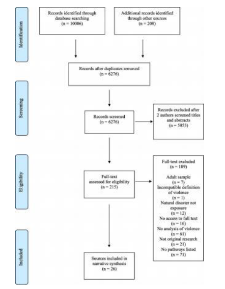
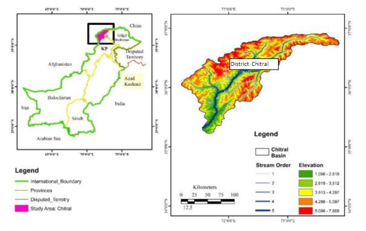
The aim of this study is debris flow risk zonation using geological and hydrometeorological indicators in district Chitral, Hindu Kush Region Northwest Pakistan. The research is based on secondary data. Multi criteria Analysis (MCA) in Geographical Information System (GIS) environment was used to achieve the objective of the study. The geological and hydrometeorological parameters were analyzed by making five classes of each parameter. The classes are ranked as most favorable and least favorable with numerical weights. The weights were assigned in accordance to their importance in debris flow occurrence. Then weighted overlay analysis techniques were applied to develop composite map representing the importance of each factor. Debris flow risk zonation map was resulted into four classes very high risk zones, high risk zone, moderate zone, low risk zone. The geology of the study area is diverse with frequents earthquakes. Similarly the forest cover is decreasing due to anthropogenic activities. The area is also characterized by long cold winters with frost action. These factors are destabilizing the slope. During summer season rain storm event results high surface runoff and peak discharge in the perennial and non-perennial channels which results flood and debris flow. These events result human life loss and disruption.  The main villages located in very high risk zone are Mulkoh, Mastuj, Reshun, Shegram, Terich Gol, Rogar, Asurat, Boni, Brep and Rech Tockhow. They have been frequently affected by hazard in the past decade. Out of the total area, very high risk zone is expanded over 8%, high risk zone is expanded over16%, moderate risk zone is 29% and the rest is low risk zone. This study has highlighted the risk zones which will help disaster management authorities and policy makers to reduce the risk of debris flow in future.

Read more

Review

The pathways between natural disasters and violence against chil-dren: a systematic review

Natural disasters are increasingly affecting a larger segment of the world’s population. These highly disruptive events have the potential to produce negative changes in social dynamics and the environment which increase violence against children. We do not currently have a comprehensive understanding of how natural disasters lead to violence against children despite the growing threat to human populations and the importance of violence as a public health issue. The mapping of pathways to violence is critical in designing targeted and evidence-based prevention services for children. We systematically reviewed peer-reviewed articles and grey literature to document the pathways between natural disasters and violence against children and to suggest how this information could be used in the design of future programming. We searched 15 bibliographic databases and six grey literature repositories from the earliest date of publication to May 16, 2018. In addition, we solicited grey literature from humanitarian agencies globally that implement child-focused programming after natural disasters. Peer-reviewed articles and grey literature that presented original quantitative or qualitative evidence on how natural disasters led to violence against children were included. The authors synthesized the evidence narratively and used thematic analysis with a constant comparative method to articulate pathways to violence.

Read more