Prevention and Treatment of Natural Disasters

Volume 2 Issue 2: December 2023

Article Article ID: 1089

Flood Prevention Strategies in China: A Review of Policies, Technologies, and Practices

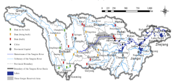
Flooding remains a persistent challenge in China, attributed to its diverse geography, rapid development, and changing climatic conditions. This article offers a comprehensive account of China's flood prevention strategies, highlighting both infrastructural measures, such as dams and urban drainage systems, and non-structural strategies, including early warning systems, land use planning, wetland restoration, and community preparedness. The discussion extends to national policies, such as the Flood Control Act and the Sponge City Initiative, along with localised governance efforts that have enhanced China's ability to manage flood risks effectively. Despite these initiatives, challenges persist due to climate change, socio-economic disparities, and the increasing occurrence of extreme weather events. Rising sea levels, intensified rainfall, and accelerated urban growth exacerbate vulnerabilities, thereby necessitating sustainable and adaptive strategies. The paper underscores the importance of integrating green infrastructure, promoting inclusive governance, and fostering international collaboration to achieve long-term flood resilience. By analyzing China's successes, limitations, and future directions, this review provides valuable insights for flood-prone regions globally, emphasising the need for a holistic and adaptive approach to flood management.

Read more

Article Article ID: 167

Overview of Circular Structures of Various Origins and Sizes in Egypt as a Contribution to Natural Hazard Data Mining Based on Remote Sensing Data and Geoinformation Systems (GIS) Analysis

This study is focused on the detection and typification of circular features with different sizes, origins, and states of erosion as well as on their surrounding tectonic setting, as well as on their impact on the environment and on the occurrence of natural hazards based on different satellite data of Egypt. Sentinel 2, Landsat and ASTER images and Sentinel 1- and ALOS L-band Phased Array Synthetic Aperture Radar (PALSAR)-radar data make it possible to identify larger ring structures as well as smaller circular features like maars or sinkholes in karst areas. Evaluations of the various satellite data contribute to the systematic and standardized inventory ring structures, most of which are related to magmatic intrusions. Such an inventory is a prerequisite for hazard preparedness and should be part of natural hazard data mining integrated into a Geo Information System (GIS). Mapping traces of volcanic activities (craters, maars, cones) is essential as a contribution to land use planning. By gathering the data and integrating the knowledge of the different ring structures in standardized GIS data base one of the many steps towards hazard preparedness and adapted land use planning can be achieved. Circular features are often buried by aeolian and fluvial sediments and become only visible on radar images or on Landsat or ASTER RGB images combining thermal bands. Larger ring structures have not only an influence on groundwater flow but also on geodynamic activity (earthquakes and related secondary effects).

Read more