Land Management and Utilization

Volume 1 Issue 4 (2025)

Research Article Article ID: 1601

Spatial Patterns in Soil Chemistry and Granulometry in the Geomorphic Hazards’ Vulnerable Land and the Need for Sustainable Utilizations

This study evaluates the patterns in nutrients, grain size, and allied matters’ distributions across geomorphic hazards vulnerable sites in Edo State to strengthen sustainable management efforts and boost land capability for agricultural uses. The specific objectives include determining the patterns of variations and relationships among the soil nutrients and allied parameters across distinct geomorphic hazards vulnerable sites. Soil samples were collected from 12 gullies and 3 flood-vulnerable sites using a soil auger and sediment corer, treated, homogenized, and analyzed in the laboratory for diverse parameters. The laboratory results were further analyzed using descriptive and inferential statistics. The grain size distributions reveal spatial fluxes, but with the unilateral dominance of sand particles. A test of multiple effects of variations in locations on nutrient endowments using Hotelling's Trace model gave a value of 13,868.621 and an F value of 3467.155 that is statistically significant at 0.013. Roy's Largest Root model offered a high value of 1850.015 and a high F value of 740.006, which is statistically significant at 0.000. The tests of variations between-subjects indicate that only phosphorus, calcium, and magnesium possessed high values that are statistically significant at a 0.05 confidence level. This study concluded that soil chemistry and granulometry in the geomorphic hazard vulnerable sites varied based on geographic locations, due to the uniqueness of the intervening human and natural agents. This study recommends the adoption of proactive people-oriented and site-specific engineering and supportive agronomic management strategies for enhanced land capability for sustainable crop production.

Research Article Article ID: 2290

Comparative Analysis of Production–Living–Ecological Space Dynamics and Driving Mechanisms in the Yangtze and Yellow River Basins

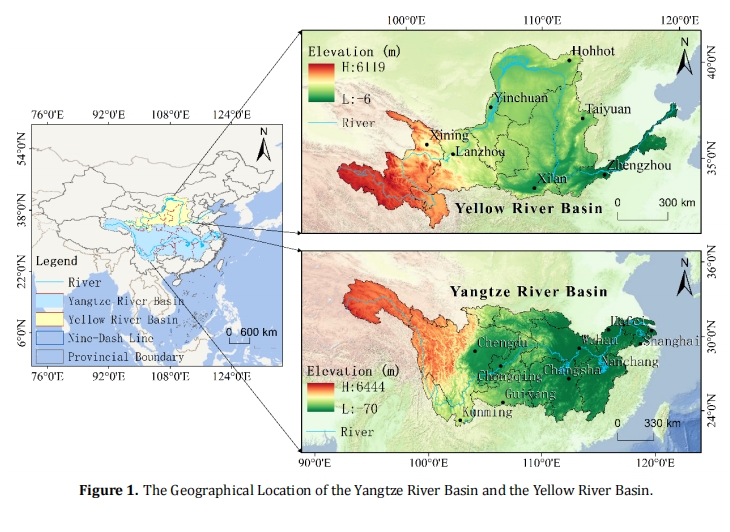
Against the backdrop of China’s ongoing regional coordinated development strategies, clarifying the spatiotemporal evolution and driving mechanisms of Production–Living–Ecological Spaces (PLES) in the Yangtze and Yellow River basins is crucial for optimizing territorial spatial governance and achieving synergies between ecological protection and high-quality development. Using PLES data from 2000 to 2023, this study integrates land use transfer matrices, chord diagram visualization, and random forest modeling to conduct a systematic comparative analysis of spatiotemporal patterns and driving factors. Results show two key findings. First, both basins exhibit a common trajectory of “agricultural production space contraction–urban living space expansion–ecological space stabilization,” yet with distinct differences in spatial configuration, temporal rhythm, and structural transformation pathways. The Yangtze Basin is characterized by production space clustering along urban corridors and notable ecological restoration, whereas the Yellow River Basin demonstrates fragmented expansion of production and living spaces, with ecological space showing a coexistence of recovery and degradation. Second, population density, nighttime light intensity, slope, and Normalized Difference Vegetation Index (NDVI) emerge as dominant drivers, but their effects differ markedly between the two basins, reflecting the differentiated impacts of policy orientations under the “ecological priority” strategy in the Yangtze Basin and the “high-quality development” strategy in the Yellow River Basin. These findings highlight the complexity of multi-dimensional drivers at the basin scale and provide theoretical and methodological insights for advancing regionally differentiated spatial governance.