Land Management and Utilization

Volume 2 Issue 1 (2026): In Progress

Research Article Article ID: 2317

Agrivoltaics in Italy: Agricultural Continuity, Authorisation, and Suitable Areas under Law No. 4/2026

Recent legislative reforms in Italy have reshaped the legal framework governing agrivoltaic installations, particularly following Law No. 4 of 15 January 2026, which converted Decree-Law No. 175 of 21 November 2025 and amended the Renewable Energy Sources Consolidated Act (Legislative Decree No. 190/2024). This article examines how the reform affects the legal classification of agrivoltaic projects and the conditions for their authorisation on agricultural land. The analysis adopts a doctrinal legal method based on statutory interpretation, review of relevant administrative materials, and comparison between the new provisions and the previous regime. It argues that the reform consolidates agrivoltaics as an autonomous legal category of integrated land use, distinct from ground-mounted photovoltaic installations, and introduces a more selective regulatory model. Key innovations include the strengthening of agricultural continuity as a substantive legal requirement, the introduction of a certified professional declaration linked to a minimum threshold of 80% of Gross Saleable Production (GSP), enhanced documentary obligations during the authorisation phase, post-installation municipal monitoring, and quantitative limits linked to the calculation of suitable agricultural areas. These measures increase the evidentiary burden on project developers and agricultural undertakings while reinforcing the protection of productive agricultural land. The article concludes that the reform establishes a more rigorous balance between renewable energy deployment and land preservation, although its practical effectiveness will depend on the development of consistent administrative practices capable of limiting territorial divergence and litigation.

Review Article ID: 2347

Sustainable Agriculture and Land Restoration: Insights from Bangladesh for Enhancing Global Resilience

Bangladesh is emerging as a key case for climate-resilient agriculture in circumstances of land scarcity and environmental stress. This review collates existing evidence towards understanding the role of sustainable agriculture practices and land restoration interventions in supporting food security and resilience. Systematic literature review following Preferred Reporting Items for Systematic Reviews and Meta-Analyses (PRISMA) guidelines, integrating peer-reviewed studies and institutional reports. The system settings include four main interventions: climate-smart crop diversification, improved soil fertility management, efficient water resource management, and ecosystem restoration. Our findings demonstrate that, although these interventions led to higher productivity and adaptive capacity of beneficiaries as compared to non-beneficiaries, their effectiveness differs greatly across agro-ecological zones due to differences in access to inputs, institutional support and adoption by farmers. In addition to descriptive synthesis, this study employs a comparative and policy-oriented perspective by highlighting the technological, ecological and institutional dimensions of agricultural transformation. The results highlight that no single intervention is sufficient, and if anything, a coordinated and adaptive approach is necessary in order to make a sustainable impact. In the end, Bangladesh’s experience is transferable to other climate-vulnerable areas in how integrated and goal-oriented approaches can lead to adjusted resilience outcomes for smallholder farming systems, achieving productivity vs. environment sustainability balance with strong governance systems and sound extension service delivery.

Research Article Article ID: 2357

Science-Based Mangrove Conservation Management in the Context of Climate Change in Pinar del Río, Cuba

Mangroves are critical for climate change adaptation but face increasing threats from hurricanes and anthropogenic pressures. Quantitative baselines for post-disturbance conditions remain limited in Cuba. We integrated field forest inventories (40 permanent 100 m2 plots) with remote sensing time series (aerial photographs: 1957, 1970, 1999; Landsat 7: 2003; Sentinel-2A: 2022, 2025) in La Coloma, southwestern Pinar del Río, Cuba. Biophysical variables (diameter, height, basal area, ecological importance value index) and seven spectral indices (Normalized Difference Vegetation Index (NDVI), Mangrove Vegetation Index (MVI), Green Cover Index (GCI), Enhanced Vegetation Index-2 (EVI-2), Normalized Difference Salinity Index (NDSI), Normalized Difference Moisture Index (NDMI), Natural Regeneration Index (IRN)) were analyzed. Classification accuracy was assessed using confusion matrix and Kappa coefficient. The mangrove forest presents low-stature structure (mean height: 4.16 m; mean diameter at 1.30 m: 5.41 cm). Total basal area was 7.41 m2·ha⁻1. Hurricane Ian (September 2022) affected 54% of individuals (351 trees). Mangrove cover increased from 6,434 ha (1957) to 7,282 ha (2022), a net increase of 848 ha (11.64%). Spectral indices revealed progressive degradation: MVI confirmed an alarming 161.8% increase (154.0 ha) in moderately degraded areas. Overall, 403.5 ha (33% of the total analyzed area) were degraded (199.4 ha highly degraded, 204.2 ha degraded), with 288.6 ha regenerating and 546.6 ha healthy. Classification accuracy was 87.3% (Kappa = 0.84). Six anthropogenic and three natural stressors were identified, including the defoliating lepidopteran Junonia genoveva affecting 80% of sampled areas. Integrating field inventories with Sentinel-2 remote sensing and GIS (Geographic Information System) enables precise post-disturbance mangrove diagnosis. The established baseline serves as a predictive tool for land-use planning and assisted restoration prioritization under Cuba's "Tarea Vida" climate adaptation plan.

Research Article Article ID: 2356

Machine Learning Innovations in LULC Classification: A Comparative Study of SVM, Random Forest, and Decision Trees

Classifying land use and land cover (LULC) is a fundamental process in remote sensing and geographical information systems (GIS) that is essential to many applications, including disaster assessment, urban planning, environmental monitoring, and natural resource management. Understanding the dynamics of landscapes and how they evolve over time requires accurate classification of land use and land cover groups. For this reason, straightforward classification methods like decision trees, artificial neural networks and maximum likelihood have historically been employed extensively. However, there has been an increasing interest in investigating machine learning techniques' potential to enhance the precision and effectiveness of LULC classification since their introduction. Computer vision, natural language processing, and remote sensing are just a few of the fields that have greatly benefited from the quick development of machine learning algorithms, especially deep learning approaches. Due to its capacity to automatically extract intricate patterns and features from massive datasets, machine learning-based techniques have become more and more popular in LULC classification jobs in recent years, potentially surpassing conventional approaches. This research paper aims to conduct a Land use classification by using machine learning based (ML) models (Support Vector Machine (SVM) model, Random Forest (RF) and Decision Trees (DT) models) with the use of open-sourced Python modules (Rasterio, Numpy, and Scikit-learn). The comparative analysis demonstrates that the SVM model achieved the highest performance with an Overall Accuracy (OA) of 97.30%, followed by Random Forest at 94.59%, and Decision Tree at 89.19%.

Research Article Article ID: 2378

Anthropogenic Drivers of Land Take—A Panel Spatial Durban Error Model Analysis for Bavarian Municipalities

This study examines the anthropogenic determinants of land take using a spatially extended STIRPAT (Stochastic Impacts by Regression on Population, Affluence, and Technology) framework applied to panel data from 1,600 municipalities in Bavaria, Germany, covering the period from 2014–2022. A Spatial Durbin Error Model is employed to account for spatial dependence and spillover effects across neighboring municipalities. Moreover, literature defines affluence typically as income or GDP per capita indicating the level of affluence of private households or regions. In contrast, the results of this paper demonstrate that (also) public affluence is a suitable indicator for explaining land take. The results show that population and public affluence exert positive local effects on land take, while urban density significantly restrains land take. Moreover, a non-linear Environmental Kuznets Curve relationship for public affluence is observed, which materializes also through spatial spillover effects. Building permissions emerge as a key policy-related driver, generating positive indirect effects that propagate land consumption across adjacent municipalities. These findings highlight that land take is not only shaped by local conditions but evolves as a spatially interconnected process driven by fiscal capacity and planning decisions. The study underscores the need for coordinated, multi-regional land-use policies and highlights the analytical value of small-scale spatial STIRPAT applications in capturing environmentally relevant development dynamics.

Review Article ID: 2411

Transforming Agricultural Land Management: Precision Agriculture, Digital Technology, and Sustainable Land Use Practices

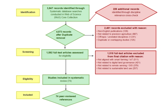
Agricultural land management is undergoing a major transformation due to the development of precision agriculture, remote sensing, geographic information systems (GIS), and data-based decision-support technologies, which are transforming the way land resources are surveyed, assessed, managed, and governed across a wide range of agro-climatic environments. This paper is a synthesis of research on the interplay between agricultural technology and land resource management, focusing on the role of digital innovations in transforming land survey, ecological restoration, land informatization, and land system reform in rural areas. Drawing from a systematic review of peer-reviewed articles published between 2010 and 2025 via the Web of Science core database and VOSviewer bibliometric tools, adoption patterns, performance outcomes, and governance implications of UAV-based field monitoring, machine learning-based soil classification, and IoT-based systems are examined. It has been shown that these technologies can be used to improve resource-use efficiency, improve soil health monitoring, aid ecological restoration, and foster equitable rural land governance. Satellite-guided systems and precision agriculture have achieved 20–30% yield gains and 40–60% reduction in input losses. Issues such as high implementation costs, limited digital infrastructure in rural areas, data interoperability, and smallholder capacity-building pose challenges. There are still knowledge gaps regarding long-term ecological effects and co-design of policies. This review proposes an integrated framework that aligns technological adoption in agriculture with sustainable land-use goals, which will help steer policymakers, agronomists, and land administrators towards the 2030 sustainable development agenda.