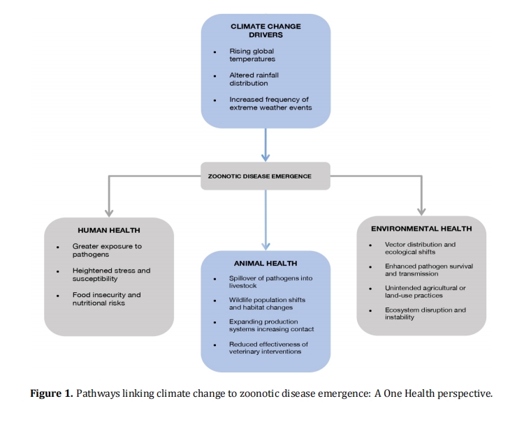
Climate change is increasingly recognized as a driver of zoonotic disease emergence, reshaping ecological interactions and amplifying risks to human and animal health. Rising temperatures, altered precipitation patterns, and extreme weather events accelerate vector breeding cycles, disrupt habitats, and intensify human-animal contact, thereby expanding opportunities for pathogen spillover. This review aims to synthesize evidence on climate‑linked zoonotic threats and examine how vaccine equity and policy integration within a One Health framework can strengthen global preparedness. A narrative literature review was conducted using PubMed, Scopus, Web of Science, and Google Scholar, covering publications from 2005 to 2025. Keywords included climate change, zoonotic diseases, One Health, surveillance, vaccine equity, and health disparities. Evidence highlights climate‑sensitive diseases such as malaria, Rift Valley fever, and leptospirosis as major global health challenges. Surveillance systems, including the Global Outbreak Alert and Response Network, the Global Early Warning System, the International Pathogen Surveillance Network, and the Global Influenza Surveillance and Response System, provide critical early warning capacity but remain unevenly implemented in low‑ and middle‑income countries. Vaccine equity challenges persist among displaced populations, rural communities, and marginalized groups, with barriers linked to infrastructure, misinformation, and systemic inequities. Embedding climate resilience, equity, and community participation into One Health strategies is essential for mitigating zoonotic threats. Strengthened interdisciplinary collaboration, digital innovation, and policy harmonization will be pivotal in advancing surveillance, prevention, and vaccine equity, thereby enhancing global preparedness against future climate‑driven zoonotic disease risks.

 246 (Views)
  262 (Downloads)